GIS Night Earth Event Files
last updated November 3, 1999
ASCA GOF releases the new GIS night earth event files. All the night earth data taken from 1993 June to 1999 August have been accumulated, and standard screening has been already applied. Total exposure time is ~13 M seconds and total number of events after the screening are ~1.6 million per sensor. Users may extract background energy spectra or images from these event files using xselect. These night earth data will be useful in the GIS data analysis to estimate or subtract non-X-ray background.
The present dataset supersedes the old night earth data
set released in July 1994 at
ftp://heasarc.gsfc.nasa.gov/caldb/data/asca/gis/bcf/bgd/night_earth, which will
be kept for archival purpose.
Main differences between the old and the new datasets are the following:
Total exposure times and counts for the event file with the Standard screening (already applied) and those after a further Strict screening are the following:
Exposure time (sec) | Total Counts | Counting rate (cts/s) | ||
|---|---|---|---|---|
| Standard Screening | GIS2 | 1.330e7 | 1,564,187 | 0.118 |
GIS3 | 1.308e7 | 1,604,001 | 0.123 |
|
| Strict Screening | GIS2 | 1.114e7 | 1,257,382 | 0.113 |
GIS3 | 1.095e7 | 1,283,429 | 0.117 |
Note that the difference of the exposure times for GIS2 and GIS3 is due to that there was a period when the GIS3 CPU had a malfunction (1994 March), while GIS2 CPU was working normally.
Where to find the new GIS night earth dataset
The event files, g2_night_earth.evt and g3_night_earth.evt are in the HEASARC ASCA CALDB directory, ftp://heasarc.gsfc.nasa.gov/caldb/data/asca/gis/bcf/bgd/night_earth_1999. These are the event files which you may directly read with xselect (however, there is a caveat; see below).In addition, if your are going to carry out further advance background study, other support files are found at the same directory.
How these files have been made
The night earth event data are extracted in the pipe-line processing at GSFC ADF, and archived at ftp://heasarc.gsfc.nasa.gov/asca/data/trend/rev2/darkearth. From all the GIS event files there, only the standard mode data are selected with the criterion PHA_BINS==1024&&RISEBINS==32&&RAWXBINS=256&&RAWYBINS=256&&TIMEBINS==1&&S_DISCR='ON'&&DATAMODE=='PH'&& NEVENT >0. Furthermore, events are screened with the following criterion:SAA==0&&ACS==0 && COR > 4 && (G2_H0+G2_H2+G3_H0+G3_H2)<45 && (G2_H0+G2_H2+G3_H0+G3_H2)<0.45*COR**2-13*COR+125 && RBM_CONT <100&&ELV<-5 &&G2_L1>0.0&&G3_L1>0.0.This is the same as the pipe-line processing and ascascreen standard screening criteria, besides ELV<-5 (pointing the earth). In addition, the standard gisclean and region selection are applied to carry out the rise-time filtering and to discard the outermost region and the calibration source. Therefore, for most users who adopt the same standard screening criteria for their observations, these background event files can be used without further screening.
How to use these files
These background event files comply the HEASARC standard, so any standard astronomical tools should be able to read them. In any case, xselect is the standard tool to reduce ASCA data, with which you will be able to extract the background spectra, images and light curves (see below for examples). You may specify the same detector region as your source observation to extract the background spectrum, which is readily used in xspec to subtract the non-X-ray background. You might want to apply a time-filter to select only the data taken at around the time of your observation, to alleviate the long term background variation (see below).Also please refer to the
ASCA mkgisbgd ftool page, in order to create GIS blank sky background images
and spectra.
Further "Strict" Data screening
If you want to apply the
"Strict" screening criterion to reject the "soft-flare" background events,
you may use the
gis_dark_earth_strict.gti file found in the same directory as the event files.
Caveat
These event files have ~32,000 GTI rows, which exceeds the default maximum number of the GTI entries extractor may handle (at least up to version 3.59). The updated binary executables of extractor to be able to handle large number of GTIs are available for major platforms, as well as the source code. We suggest to obtain the latest binaries from http://heasarc.gsfc.nasa.gov/docs/software/ftools/ftools_update.html.Alternatively you may want to increase the GTI number upper-limit by editing the following part of expar.inc found in $FTOOLS/../src/heasarc/src/extractor/,
  * Maximum number of Good Time intervals and time windows combined

	INTEGER*4 MAXGTI
	PARAMETER (MAXGTI=10240).
Then you may rebuild the extractor by entering "hmake" in the extractor directory after "source $FTOOLS/BUILD_DIR/devinit.csh". This procedure applies only if you have built the ftools from the source package on standard Unix platforms.
Example of Background Spectra and Images
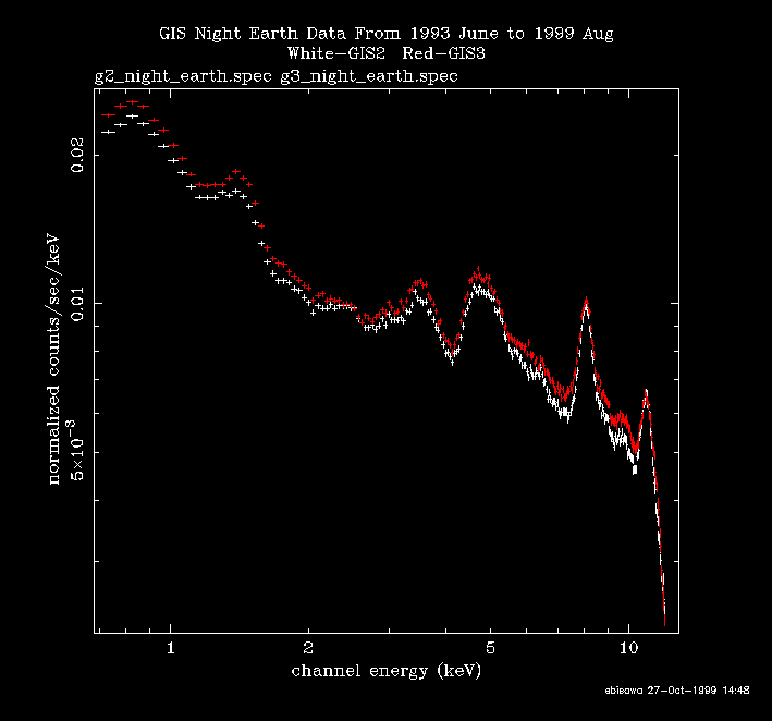
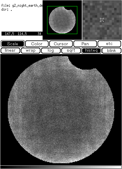
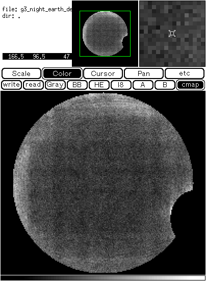
No GTI selections are made to create following images and spectra from g2_night_earth.evt and g3_night_earth.evt.g2_night_earth.spec and g3_night_earth.spec
Note that the sharp peak at 8 keV is the instrumental fluorescent Cu-line which is used to determine the absolute GIS energy scale (see Status of the GIS gain calibration page).
g2_night_earth_det.img and g3_night_earth_det.img
Long Term Variations
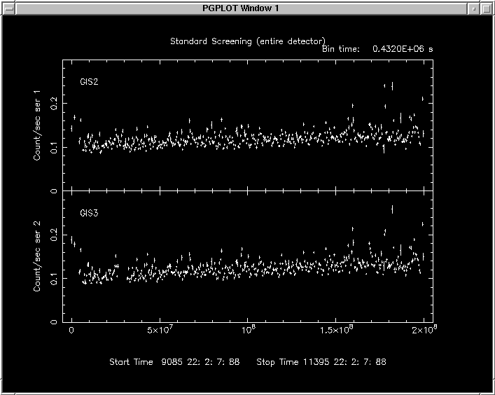
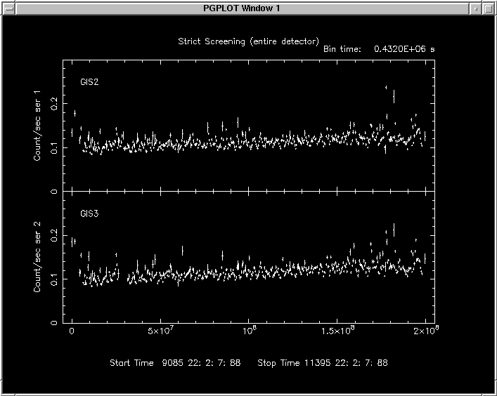
The following figures indicates long term variation of the GIS night earth background. The bin-width is 432,000 sec (5 days). A gradual increase is recognized.The gis_dark_earth_strict.gti file is used to apply the "Strict" criterion. If you compare results with the "Standard" and "Screening" screening criteria, you can see that fluctuation at a timescale of days will get smaller when the "Strict" criterion is used.
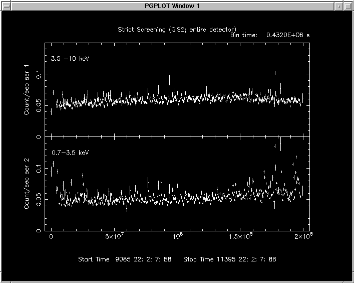
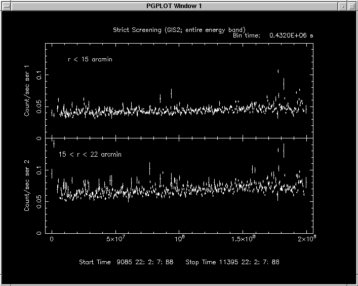
The following two figures indicates energy and position dependence of the long term variation. It seems like the long-term increase is more significant at outer-par of the detector. Dependence of the long term variation on the energy band indicates the background energy spectrum has varied with time.
Support Files and Further Studies
Following support files are also available for
further advanced background study.
For further details of the GIS background characteristics,
please refer to the article "Reproducibility of the GIS Non X-ray Background "
by Ishisaki et al. in ASCA Newsletter vol. 5 and
Y. Ishisaki's doctoral
thesis entitled "Spectra and Large-scale Isotropy of the Cosmic
X-ray Background from ASCA Observations".
GTI corresponding to the
"Standard" criterion
for all the GIS night earth observation through
1993 June to 1999 August. This was used to create the
g2_night_earth.evt and
g3_night_earth.evt files.
GTI corresponding to the
"Strict" criterion
for all the GIS night earth observation through
1993 June to 1999 August.
gis_dark_earth1994.mkf:
gis_dark_earth1995.mkf:
gis_dark_earth1996.mkf:
gis_dark_earth1997.mkf:
gis_dark_earth1998.mkf:
gis_dark_earth1999.mkf:
Filter files having only GIS related
parameters when GIS is pointing the night earth for each year.
If you have any questions concerning ASCA, visit our Feedback form.

